Remembering the Chase
To tell the story of Cannock Chase through time the project held a commemorative event in June 1917. Particular focus resting upon the Great War camps as a link to the Centennial commemoration. Particular focus was on the role of the New Zealand Rifle Brigade, the battle of Messines and its connection to Cannock Chase Centenary commemoration.
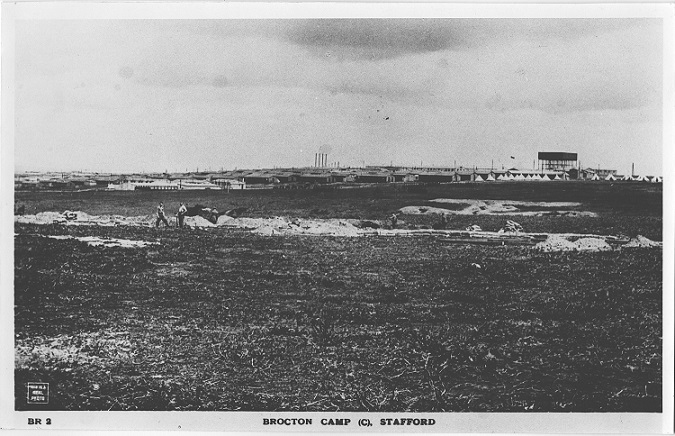
In the autumn of 1914, only months after the start of the First World War, construction of two large camps began on Cannock Chase.
The camps, known as Brocton and Rugeley were constructed with the permission of Earl of Lichfield, on whose estate they were being built. During the early part of the war the camps were primarily used as transit camps to accommodate Service Battalions travelling towards the western front; following their completion, the camps became a training facility and there was a steady influx of battalions.
As well as standard infantry training, various schools of war were established, offering instruction in sniping and reconnaissance, signalling, physical training, gas warfare and many other related subjects.
Some four miles away was the historic county-town of Stafford whose people proved to be eminently kindly and hospitable. The camp itself was thoroughly equipped for all branches of general and specialist training, the open spaces offered ample scope for close order work, while the climatic conditions, combined with the nature of the soil, gave a realistic touch to the frequent rehearsals in trench routine and attack and defence.
The New Zealand Rifle Brigade, who later made Cannock Chase their UK, headquarters where one of the colonial units stationed here during the war. They were based close to the German Prisoner of War Camp in Brocton Coppice and the remains of many of their hut lines survive today.
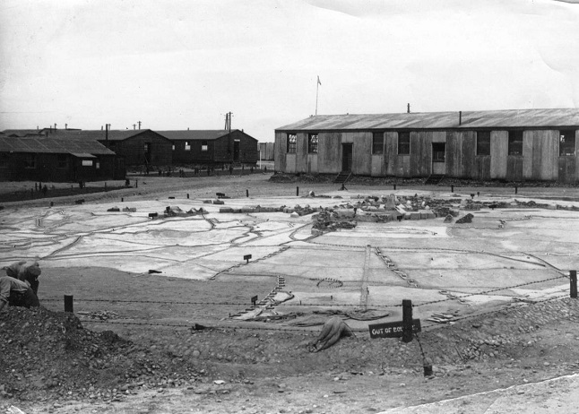
In 1918 troops from the New Zealand Rifle Brigade created a scale model of the town of Messines on Cannock Chase in Staffordshire where they had their training camp. The Rifle Brigade had played a crucial role in the capture of Messines in June 1917 and the model served both as an instructional tool and a memorial to fallen comrades.
To find out more about the Messines story, visit the story map here. This online resource expertly blends historic and modern mapping and photographs to tell and illustrate the story of the Battle of Messines (June 1917) and its link to Staffordshire. The Story Map provides an insight into the lead up to the Battle of Messines and traces in detail how the battle unfolded, the role of the New Zealand Rifle Brigade, and the aftermath of the battle. It also provides an insight into the two Great War training camps located on Cannock Chase, and the scale model depicting the Battle of Messines built by the NZRB. This model was revealed during excavations in 2013, and has since been designated as a Scheduled Monument, and it is a key element of one of the most significant Great War Landscapes in Britain.

“Remembering the Chase” was a commemorative event with costumed interpreters portraying events and people from Cannock Chase’s past including prehistoric groups, medieval hunters and metal workers of the industrial period. It featured hands on living history displays recounting the training at the Great War camps and highlighting the role of mining operations in the lead up to the assault on the Messines Ridge in June 1917.
This free family event allowed old and young alike to get up close and talk to many of the Chase’s past residents to discover how they lived their lives and how they changed the landscape of Cannock Chase for generations to come. The event also hosted a short play, poetry readings and demonstrations centred around the Cannock Chase camps during the Great War.
The event show cased the work of partner organisations including the Area of Outstanding Natural Beauty Unit, Historic England, the Friends of Cannock Chase.
The project aims to train teams of volunteers to accompany the Historic England investigators in field work, to ground truth the features identified on the LiDAR and further understand what is being recorded on the images. Much of this training will take place on the Chase, and due to the nature of the work will mainly be carried out over the winter. It also aims to develop the skills, experience and confidence of a volunteer group including experience in: recognising earthworks in a variety of locations/topographies, using digital recording, photography, assessing extent, nature, condition and threats in a site-based situation and working in small groups.
Field work will take place across Cannock Chase and will be determined by the LiDAR results. Volunteers will receive full training, equipment and support for the field work, including First Aid training. As part of the project we will have developed a special Field Recorder App to support our volunteers in the field.
The Staffordshire Archives Service holds a wealth of records concerning the development and management of Cannock Chase throughout the post-medieval period. The Chase through Time project used these resources to investigate the process of change across this sensitive historic landscape.
A technical expert working with the Staffordshire Record Office team and the Chase through Time project coordinator led a group of volunteers in researching the various aspects of Cannock Chase’s development over the past 350 years. The group considered a range of historic sources including manorial records, court rolls, estate maps, tithe maps (and apportionments), enclosure awards, contemporary accounts, game books, other early maps, prints, paintings, illustrations, engravings and photographs.

The primary aim of the historic research was to develop an understanding of man’s influence on the development of the Cannock Chase landscape between 1600 and 1970 and answer the question of why, by 1950, did the Chase looked like it did?
To help determine this a series of themes were investigated, including:
The impact of land management for hunting and other amenity purposes (i.e. deer/grouse hunting, walks/rides, picnic sites/viewpoints) upon the Cannock Chase landscape.
Evidence for the construction/maintenance of wood banks and hollow ways across Cannock Chase.
The development of agricultural practices on the fringes of Cannock Chase and consider how and why such activities took place (whether legal or illegal).
The development of farm infrastructure (field systems, farm complexes, roads, lanes and hollow ways) and the historical process of enclosure across this landscape.
Due to the apparent strengths and weaknesses of the available archive material the research ended up focusing much more closely on the later eighteenth and earlier nineteenth centuries. In doing so, it was best placed to offer a view of the Chase that was substantially different from its current character and usage. This also complemented other strands of the Chase through Time project, some of which were more heavily focused on the later history of the Chase, in particular the Great War camps.
The results of the research are summarised in the full archive research report.


